
You’re about to dig up your backyard to install a new fence, but you’re worried about hitting underground pipes or cables. Or maybe you’re a contractor who needs to know exactly what’s beneath a construction site before breaking ground. This is where ground-penetrating radar (GPR) comes in.
GPR has quietly become one of those technologies that make modern life safer and more efficient. In this blog, you’ll learn what GPR is and how it works.
Table of Contents
What Exactly Is Ground Penetrating Radar?
Ground-penetrating radar is a geophysical way of knowing what’s underground. But instead of using light like a regular camera, it uses electromagnetic waves, which is similar to the radio waves that carry your favorite FM station, but just at different frequencies.
A device sends radar energy down into the ground. When those waves hit a water pipe, an old foundation, or a change in soil type, some of that energy bounces back up to the surface. The device catches these returning signals and uses them to create an image of what’s down there.
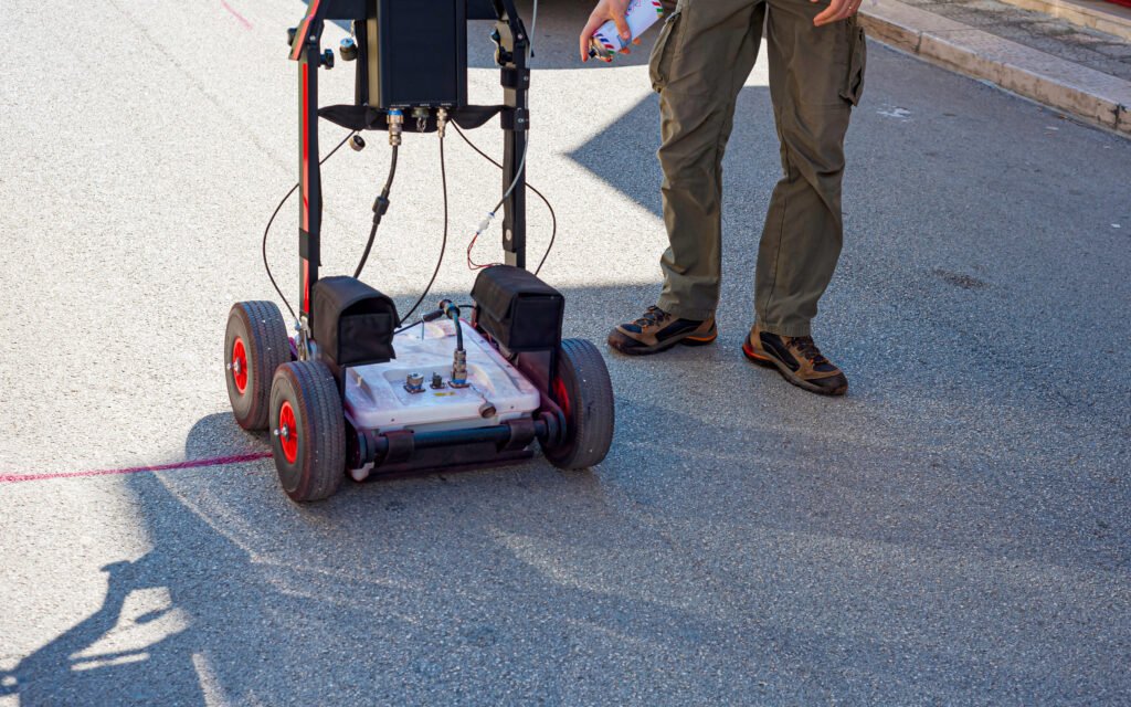
This method is useful because it doesn’t disturb anything. You’re not digging exploratory holes or drilling test sites. You’re simply rolling equipment across the surface and getting a detailed look at what lies beneath. For utility locating work, this means you can map out buried objects like electrical conduit and water lines before anyone picks up a shovel.
Breaking Down How It Works
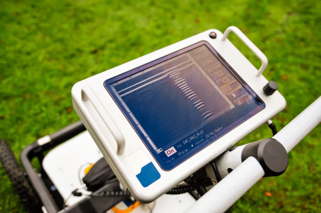
The main parts include the control unit, an antenna that sends and receives the electromagnetic radiation, and a power supply to keep it all running. Modern systems also include a digital storage device so you can save and review the data later.
The antenna frequency is where things get interesting. Different frequencies are good for different jobs. Low-frequency GPR systems use electromagnetic energy in the range of 10-200 MHz. These can see deeper underground, sometimes 30 meters or more in the right conditions. But they give you a fuzzier picture.
High-frequency GPR systems, operating between 200-3000 MHz, work the opposite way. They give you incredibly sharp, detailed images, but they can only see a few meters down. It’s a constant trade-off: depth versus detail.
The electromagnetic technique works because everything underground has different dielectric properties. When radar energy traveling through dirt suddenly hits a metal pipe, the change in material properties causes some of that energy to reflect up. The bigger the difference in dielectric constant between two materials, the stronger the reflection you’ll see.
Companies like Pulse Locating have built their entire business around this technology, using advanced equipment for subsurface utility detection. These reputable companies figured out how to read these underground signals and translate them into actionable information for construction crews, engineers, and property owners who need to know what’s beneath their feet.
Making Sense of the Data
When GPR equipment sends electromagnetic waves into the ground and receives them back, it’s measuring something called two-way travel time. It’s basically how long it took for the signal to go down, bounce off something, and come back up.
Since we know roughly how fast these waves travel through different types of subsurface materials, we can calculate depth accurately. But as electromagnetic energy travels through the ground, it gets weaker. This is a process called signal attenuation.
Some soils are particularly brutal to radar signals. Clay-rich soil and anything with high electrical conductivity will absorb the signal quickly, which means you can’t see as deep. On the flip side, dry sandy soil, solid rock, and ice are much friendlier to GPR. The signal travels farther and stays stronger.
The visual output from a GPR survey typically shows a cross-section of what’s underground. Buried objects show up as curved, hyperbolic shapes on the screen.
Experienced operators can look at these patterns and tell you whether you’re seeing a pipe, a cable, a void, or just a change in soil composition. More sophisticated analysis can produce depth slices (horizontal views at specific depths) that show you the layout of everything at that level.
When you combine GPR data with other technologies like 3D laser scanning, you can create incredibly detailed digital twins of a site. This is especially valuable for BIM modeling in large infrastructure work, where knowing exactly what’s underground can save millions in avoided delays and accidents.
Understanding the Limitations
GPR isn’t perfect for every situation. The target size matters quite a bit. Smaller objects are harder to detect and require a higher antenna frequency, which means you can only see them if they’re close to the surface.
Ground conditions can also make or break a GPR survey. Highly conductive soils, especially clay or soil saturated with saltwater, can reduce your effective depth to just a few inches. In these conditions, you might need to consider alternative geophysical applications like seismic surveys or other methods.
Equipment quality varies dramatically, too. Consumer-grade GPR units might cost a few thousand dollars, but they won’t come close to matching the performance of professional systems from companies like GSSI GPR equipment, which represents the industry standard for serious subsurface imaging work.
You also need someone who knows what they’re doing. Reading GPR data isn’t always straightforward. Those hyperbolic curves could be pipes, rocks, or tree roots. Understanding instrument configurations, proper GPR frequency selection, and how to interpret complex reflection patterns takes training and experience.

What’s Next for GPR Technology
The technology keeps getting better. Modern systems are more portable, easier to use, and more affordable than ever. We’re seeing GPR integrated with other tools like LiDAR technology and drone photogrammetry to create comprehensive site assessments. Some companies are combining GPR with CCTV video cameras for pipe inspection, or pairing it with laser scans to create detailed 3D Virtual Tours of sites both above and below ground.
The future probably holds even more integration. Imagine pulling up to a construction site and using a tablet to see a full augmented reality view of everything underground, powered by GPR data, utility maps, and reality capture services all working together. We’re not far from that reality.
Final Thoughts
Ground penetrating radar remains one of the most reliable ways to answer a simple but critical question: what’s down there? Whether you’re a homeowner planning a renovation, an engineer designing a new building, or a contractor trying to avoid an expensive mistake, GPR gives you the information you need to work confidently and safely. It’s turned underground investigation from guesswork into science, and that’s made all the difference.